


Ancient Bridport Harbour
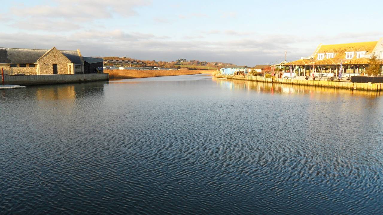
Looking north over Ire Pool from the harbour sluice gates
The location history of Bridport Harbour prior to its major reconstruction in 1740 is controversial, the purpose of this report being an attempt to clarify this area of confusion. It had been claimed in a report by Henry Symonds(1) dated 1912 that the original position of the ancient harbour and estuary of the River Brit had been much closer to East Cliff. Since then it has appeared as a reference within other reports and books.
For clarification, the author will refer to the harbour as follows:
- Ancient Harbour - Prior to its major reconstruction in 1740
- Old (Inner) Harbour - Current harbour just south of the sluice gates built after 1740
- Outer Harbour / Marina - Contained within the new East and Jurassic Piers built in 2005
When you stand on the current sluice gates bridge and look to the north, the small lake in front
of you is possibly the remnants of the ancient harbour.
'Ire Poole or Pool' played an important part in the ancient harbour's location. It had two possible positions.
On a plan of the old harbour in 1828, it is marked as being by the pool of water just to the north of the current sluice gates.
However, an 1833 borough boundary map (Reform Act 1832) and description puts Ire Pool at the first tight bend upstream on the
River Brit (at the northern end of the West Bay Holiday Park). Unfortunately there are errors on this latter map, the
River Asker being referred to as Asher, Downe Hall spelled without the 'e' and an unheard of 'Wareham Gate' on the
Harbour Road (now West Bay Road) just north of Haddon House. So is the precise location of Ire Pool also an error or perhaps
its position altered deliberately to make boundary reference points easier?
'Ire' (pronounced 'Higher' but without sounding the 'H') is Latin for 'angry' and could have referred
to the river's turbulent state after passing through the ancient harbour's sluice gates.
We can assume that Ire Pool (Angry Pool) existed near the current sluice gates.

Harbour Plan 1828 (James Green)
Ire Pool location circled in red

Borough Boundary Map 1833
Ire Pool location circled in red
According to Hannah(2) and Keystone(3), the Act of Parliament 1721-1722 (Bridport Harbour Act) to build a new harbour, mentions Ire Poole, the northern part of the ancient harbour. Hannah(2) then goes on to say 'In January 1740, John Reynolds, an engineer from Cheshire, agreed to build the (new) harbour on its present site’. Silting had always been an issue, hence sluice gates. However, Reynolds probably installed the gates across Ire Pool to produce a much stronger purging action to flush the silt. However, Ire Pool would no longer be an angry pool.
Controversy
Symonds(1) makes some persuasive arguments for the River Brit having run closer to East Cliff in the past rather than always being on its present course.
- During the 13th Century, the Abbot of Cadomum (Burton Bradstock for the east river bank) demanded shipping tolls, whereas the Abbot of Cerne (Symondsbury for the west river bank) did not.
- A 1740 Article of Agreement made by John Reynolds states: 'to turn the course of the said river...shall in future run in through and between the said footwharfs and piers'. He claims this could imply diverting the river's original course.
- Book of Accounts 1744 states: 'Building the piers there and digging the channel'. Again he claims this could imply diverting the river's original course for a new channel to the sea.
- Though also mentioning Ire Pool, he states that from records, a compulsory order was made to purchase land to its south for constructing the (new) harbour.
- Land abutting on East Cliff is the lowest portion of open ground where a stream would seek an outlet. He then uses examples of the River Bredy (Bride) and River Axe as being estuaries next to their respective East Cliffs.
- Trial holes (in 1885) by Edward Prior for possible building foundations at the foot of East Cliff, found the subsoil consisted of loose sand, consistent with an old river.
- The old Symondsbury boundary 'follows the river from town (Bridport) to the harbour, then quits the stream and turns eastward to the sea near East Cliff'.
Many of the above points could be open to contention and as I had always been somewhat sceptical,
decided to delve further, especially with Symonds(1) claim of number 7 above. The information I discovered totally
transformed my views. Not only did I find very convincing proof that the ancient harbour and river estuary were close to
East Cliff but now also knew the location and river’s course with reasonable accurately.
The two pieces of evidence that reinforces Symonds(1) and now my belief that the ancient harbour and river estuary
were once close to East Cliff are an old parish boundary map of the Reform Act 1832 and an etching of West Bay dated 1822.
The boundary map shows the old Symondsbury parish boundary crossing East Beach, while the etching by William Daniell
shows shading on East Beach, implying a basin consistent with a dried up harbour or river bed.
It is only an etching but the artist has drawn what he has seen.

A Voyage Round Great Britain, 1822 - etching
William Daniell (1769 - 1837)
Tate Gallery Collection

Symondsbury Boundary Map 1832
Symondsbury Parish Boundary
Working from this information, plus dates of old buildings in West Bay, I was able to draw a map of the predicted location of river and ancient harbour. Good’s Yard was built around 1771, after the harbour was moved but before the William Daniell etching, so the harbour had to avoid that area. A pair of old cottages called the Customs House or Old Castle (but probably neither) sat outside the eastern entrance of Good’s Yard and possibly predated The Sloop (Bridport Arms). They were derelict and demolished about 50 years ago but might have stood in the times of the ancient harbour. The Neptune (West Bay Hotel) was built just before the ancient harbour was moved, so the route to Ire Pool would have roughly followed the current road back to the sluices. This latter area would have been the first to be filled in from the spoils of the (new) old harbour and buildings there are relatively new (St John’s Church and the shops), the only exception being Seagulls Restaurant, built in the early to mid 19th century. Finally, for Ire Pool to be an angry pool, the sluice gate must have been just north of it, bridging the River Brit.
Referring to the 1832 parish boundary map, the boundary takes a straight line across East Beach but was unlikely in reality. Taking account of errors on the map, the straight line was probably a convenience rather than a reality, considering that the map was drawn almost 100 years after the river diversion and harbour relocation took place. Symonds(1) reports that the base of East Cliff was the lowest point and Edward Prior’s test bores in that area implied a river bed. Therefore the River Brit could not cross in a straight line and satisfy those findings, so the parish boundary presumably followed the river. The parish boundary map would claim the Bridport Arms to be in the Parish of Burton Bradstock but prior to 1740 it was probably in the Parish of Symondsbury.
In 1740 the area was known as Bridport Harbour and the assumed layout is shown below
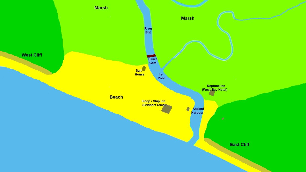
Map of the assumed location of the Ancient Harbour and River Brit Estuary prior to 1740
Just before work started to relocate and build the (new) old harbour
Map of the assumed location of the Ancient Harbour and River Brit Estuary
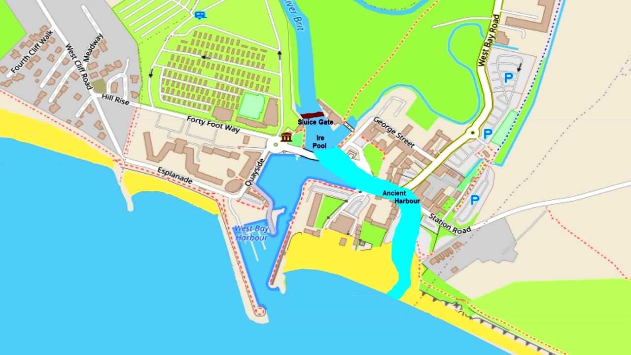
Superimposed on a modern map (openstreetmap.org) - 2021
Inland Harbour
13th century records indicate that the River Brit was navigable as far inland as Bridport at high tide by small flat bottomed ships with a shallow draft. Reports suggest there might have been a small inland harbour, possibly located close to where the A35 by-pass now crosses the River Brit, though it probably only consisted of an unloading wharf. The land between the ancient harbour on the coast and Bridport itself had consisted mainly of marsh, making the transporting of cargo difficult by horse and cart. Therefore incoming ships would have unloaded their cargo at the ancient Bridport Harbour and onto flat bottomed barges to transport it up the River Brit to Bridport Town's unloading wharf.
Conclusion
I (the author and retired electronics design consultant) had lived in West Bay for 20 years at the
time of writing this report and spent many years looking for evidence of the ancient harbour and River Brit estuary
having been close to East Cliff in the past. No signs could be found. Because plans and location maps of the ancient harbour
and River Brit estuary do not seem to exist, it is difficult to prove beyond all doubt as to their pre 1740 location.
Without Symonds(1) hypotheses, the question probably would never have arisen but evidence is now overwhelming that he was correct.
It had been suggested that after reaching Ire Pool (by the current sluice gates), the river then looped back behind the
boat yard and Haddon House, following the run of the current brook but flowing in the opposite direction.
Upon reaching Ire Pool, the only obstacle between the river and sea was sand, the 1740 purchase description of the land
south of Ire Pool being described as 'a sandy waste'. Water would permeate through sand far more readily than clay soil.
There needs to be consideration as to why Ire Pool (Angry Pool) derived its name. Sluice gates in the position I've suggested
would be ineffective if the river then looped back. Also, the Salt House was built to aid fishermen during times of the
ancient harbour and its position needed to be convenient to load salt onto boats.
When you stand on the current sluice gates bridge and look to the north, what do you call the small lake in front of you?
I have always referred to it as the River Brit Basin. Perhaps it should be called Ire Pool, the northern position of the ancient harbour.
Author:
John R May, report prepared 2021Acknowledgement:
Sylvia Stafford (local historian) for documentary helpBibliography:
- Symonds, H. Bridport Harbour Through Seven Centuries. 1912
- Hannah, G W. The evolution of Bridport Harbour. 1986
- Keystone Historic Buildings Consultant, West Bay Dorset Historical Report. 1997